|
THE HISTORY OF OUR GREEN SPACES
No.6: BLACK WOOD
Yates & Perry's 1768 Map of the Environs of Liverpool - one of the earliest detailed maps of our area to be published - indicates Black Wood as an unnamed patch of woodland alongside the words 'Childwall Heath'. That name is a reminder that, until the mid 18th century, much of the landscape between the villages of Wavertree and Woolton consisted of uncultivated 'waste' or common land. The extensive tree cover which had existed in ancient times had been eroded to such an extent that only a few areas remained. The patch of woodland on the map straddled a road (the present-day Woolton Road) which on the 1768 Wavertree Enclosure Map was described as the new "Road from Hamiltons Firs Nook towards Gateacre".
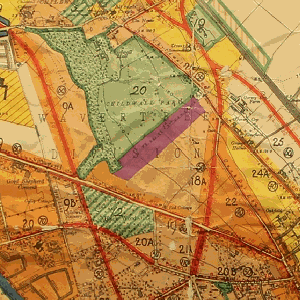
As was the case with much of the other land in the Childwall and Little Woolton townships, Black Wood was owned, in the mid-19th century, by the 2nd Marquess of Salisbury. He had inherited it (along with the title of Lord of the Manor) as a result of his marriage to Fanny Gascoyne, the only child of Bamber Gascoyne of Childwall Hall. By the mid-20th century, with the rapid expansion of suburban Liverpool, there was intense pressure on land for development - but also recognition of the amenity value of features such as the ancient woodlands. A plan - the Liverpool Town Planning Scheme No.2 - was adopted in 1933 to regulate the development of Childwall, Gateacre and the surrounding area. It specified areas for low density and higher-density housing, and for business uses. It proposed a network of new roads (such as Childwall Park Avenue and Gateacre Park Drive) to open up these areas for development. The Town Planning Scheme also identified areas to be left undeveloped, either as private or public open spaces. One of the "proposed public open spaces" was Black Wood.
|
|


